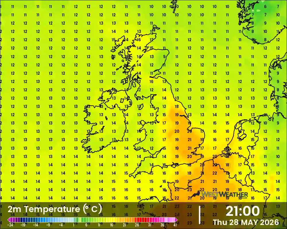
UK Temperature forecast GFS map chart animation for the next 9 days

GFS Temperature UK Weather Chart from WestWeather
Please select a weather chart:

Our GFS Temperature chart

Our temperature forecast map shows expected temps across the UK. Includes forecasts up to 9 days ahead across the UK.
Simply hit the play button or drag the slider to see what is likely to be coming our way over the coming days.

We create and upload these images four times a day and begin updating at 6.30am, 12.30pm, 6.30pm and 12.30am (BST) and take approx 110 mins to complete.

South West Warnings
    Yellow warning of wind affecting South West England: Bath and North East Somerset, Bournemouth Christchurch and Poole, Bristol, Cornwall, Devon, Dorset, Gloucestershire, Isles of Scilly, North Somerset, Plymouth, Somerset, South Gloucestershire, Swindon, Torbay, Wiltshire valid from 0000 Fri 24 Jan to 2359 Fri 24 Jan Yellow warning of rain affecting South West England: Bath and North East Somerset, Bournemouth Christchurch and Poole, Bristol, Cornwall, Devon, Dorset, Gloucestershire, North Somerset, Plymouth, Somerset, South Gloucestershire, Swindon, Torbay, Wiltshire valid from 0800 Sun 26 Jan to 0600 Mon 27 Jan Yellow warning of wind affecting South West England: Gloucestershire valid from 0500 Fri 24 Jan to 1500 Fri 24 Jan Yellow warning of wind affecting South West England: Bath and North East Somerset, Bournemouth Christchurch and Poole, Bristol, Cornwall, Devon, Dorset, Gloucestershire, Isles of Scilly, North Somerset, Plymouth, Somerset, South Gloucestershire, Torbay, Wiltshire valid from 0800 Sun 26 Jan to 1500 Sun 26 Jan
On This Day ...
Record Temperatures On This Date
Record High
12.3°C- 2024
Record Low
-5.7°C - 2015

Moon & Sun Forecast

Sunrise
7:59 am
Sunset
4:40 pm
Day Length
08:41 hrs
Waning Crescent, Moon at 23 days in cycle
Moonrise
2:51 am
Moonset
11:00 am
Visibility
32%
There will be 2 mins 55sec more daylight tomorrow
Moon Phase:Waning Crescent

Climate Extremes

Thursday 23 January
High Temp6.8°C11:36 AM
Low Temp-1.1°C1:26 AM
Rain Today 3.3 mm12:13 PM
High UV0.0 12:00 AM
Max Gust23.0 mph11:04 AM
Min Windchill11.1°C12:00 AM
So far this month
High Temp11.3°C5/1/2025
Low Temp-5.6°C11/1/2025
Wettest Day12.1mm6/1/2025
High UV0.01/12/2024
Max Gust35.4mph1/1/2025
Min Windchill-8.3°C11/1/2025
So far this year
High Temp11.3°C5/1/2025
Low Temp-5.6°C11/1/2025
Wettest Day12.1mm6/1/2025
High UV0.030/5/2024
Max Gust35.4mph1/1/2025
Min Windchill-8.3°C11/1/2025
All time records
High Temp35.5°C18/7/2022
Low Temp-10.8°C20/12/2010
Wettest Day80.2mm20/7/2007
High UV18.013/6/2022
Max Gust62.1mph23/2/2017
Min Windchill-21.1°C15/02/1963